We said farewell to Quartzsite for another season and
traveled to the Verde Valley Fairgrounds in Cottonwood, AZ. It is a rather noisy place with road traffic,
it presents little aesthetic value, but it offers a central point to tour
Sedona. They have a dump station on the
premises and have several electric/water hookup sites for $25/night. We were fine with boondocking at a rate of
$15/night. I wanted to boondock in
Coconino National Forest, but Dad had concerns about maneuverability and road
conditions since precipitation is expected.
Furthermore, he read several accounts and had been told by two RVing
friends that living conditions are far from optimal. Apparently, the area is getting overcrowded,
trashed, and riddled with human feces. Yuck!
We had intermittent rain showers and cooler temperatures
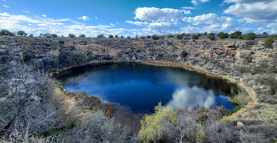
when we visited Tuzigoot National Monument the next day. Tuzigoot, meaning “crooked river”, was the
dwelling place of the Southern Sinaguas for several hundred years. Built between 1000 and 1400 A.D., the
original pueblo is believed to have been 2 stories high with 110 rooms, 87 of
which were on the lower level. Prior
cultures hunted and gathered in the Verde Valley for eons. However, it was not until 700 A.D. that the
Hohokam people turned to farming. The
Sinaguas that followed thereafter cultivated the fertile plains of the Verde
Valley.
I was diligent in reading all the placards in the Visitor
Center, earning myself a Junior Ranger badge for my efforts. We hiked all the trails on the property,
which provided gorgeous vistas. More
importantly, I attained a greater understanding of the role of the Verde River/Tavasci Marsh, whether for ancient civilizations, European ranchers, or migratory
birds.
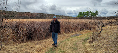 |
| Hiking the Tavasci Marsh |
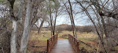 |
| The view of Tuzigoot from one of the hiking trails |
We were happy to learn that friends Tina/Johnny (we met in
2019 while volunteering at the Great Swamp Wildlife Refuge in NJ) were also
touring the area. They stopped over to
visit upon our arrival at the Fairgrounds, and we made plans to meet up for
dinner in Old Cottonwood. We hopped on Dad’s
trike Maximus (a converted Harley-Davidson 2010 Road King Classic) and headed
in early to give us time to explore the shops.
Unfortunately, we got caught in a downpour just as we got onto Main
Street. To top it off, many of the shops
were already closed for the day. We may
have trudged through the rain, but we were rewarded with a colorful rainbow as
we entered Adrianna’s Mexican Restaurant.
What a great place! We were all
overwhelmed by the generous portions, reasonable prices, and freshness of the
ingredients. But this restaurant really
scored my 5-cheese award when Adrianna herself catered to Dad’s dietary needs
and cooked his meal from scratch—steamed veggies instead of sauteed in oil,
fresh avocado and pico de gallo. We
had a blast seeing Tina/Johnny again, and we made plans to hike with them the
next day along the Bell Rock/Courthouse Butte Loop Trail in Sedona. But sadly, Tina/Johnny had a death in the
family in Louisiana, so had to leave first thing in the morning. We went to say goodbye and extend our
sympathies on their loss.
 |
| I made a new friend in one of the shops in which we browsed! |
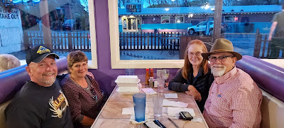 |
| Dinner with Tina/Johnny |
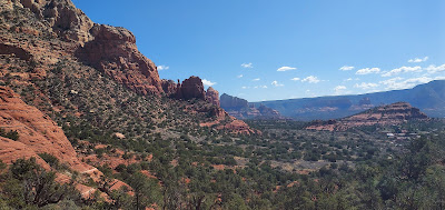
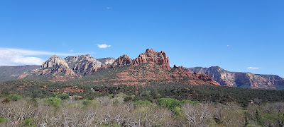
Getting a later start than anticipated, we motored into
Sedona and admired the gorgeous red rock.
We arrived by 9 a.m. at the main trailhead parking lot, which was
packed. Some advice if you go: 1) You’ve
got to get here EARLY, especially if you are climbing to the top of Bell Rock, otherwise
you will be parking in lots much further away and 2) Bring the smallest vehicle
you have! We lucked out that someone was
pulling out just as we arrived on Maximus.
Parking permits cost $5 for the day, which can be purchased at the
self-serve kiosk. Alternately, you can
just display your valid America the Beautiful/Inter-Agency Pass and park for
free. Since we had no where on the trike
to display our Pass without the possibility of it being stolen, we paid the $5
daily permit fee grudgingly.
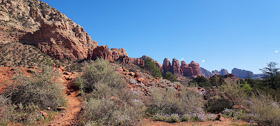
The hike was relatively easy but rocky, with some remnants
of mud from recent rainstorms. So, Mom
was glad she brought her walking sticks with her for added stability. Compared to the Bell Rock climb, the Loop
trail was not heavily populated. The
views along the Loop trail were magnificent, and evidence of Spring was
everywhere, with grasses starting to sprout and bushes starting to bloom. As we continued along the trail, we heard
beautiful tribal music resounding from Cathedral Butte. We were told that a man comes out here daily
to perform on a recorder (an instrument similar to but smaller than a flute),
perhaps connecting with his roots and culture.
We saw all the famed rock formations, from Baby Bell to the Spaceship
(or Mammogram Hill as one hiker we met along the way referred to it).
 |
| Views from the Loop Trail |
We hiked nearly 4 miles, so we were ready for some chow. We headed downtown via AZ-179, passing the
pricey galleries, holistic spas, and boutiques. Traffic was heavy, as we had been warned, but it gave me time to soak up the spectacular scenery. We arrived at our destination: the Mesa Grill at Sedona Airport. Mom and I got excited when we were handed a large, 4-page menu, reminiscent of those given at NJ diners! Oh, the choices we would have! We were disappointed to learn that 3 of the pages were for liquors and libations. The food menu, though confined to only 1 page, did have options for Dad. He had a vegan burger bowl, which contained a veggie patty, portabella mushrooms, sweet potatoes, avocado, and pica de gallo. Mom and I split the $100 Burger (which they offered at the bargain price of $18.95). The burger was layered with onions, kielbasa, cheese, and mushrooms, and came with a nice spring mix salad with fresh berries and nuts. Everything was de-lish! Add in the great views of Cathedral Rock and Apache helicopter landings along the air strip, and you’ve got a dining winner.


 |
| View of Cathedral Rock (on right) from the Airport Mesa Grill |
After lunch, we walked down to the Airport Mesa Viewing Point, where a vortex
supposedly exists. We didn’t feel
energized physically, but we were filled emotionally with a sense of serenity
and spirituality as we witnessed the majestic panoramas. We then hiked the Sedona View Trail which
leads to the Airport Loop, of which we did a portion. We clocked 8 miles over the course of the day,
and we even logged a geocache! It was a
glorious day, a day to praise our Creator and express thankfulness for the
opportunity to view the magnificent wonders before us.

We had reservations to visit the cliff dwellings at Palatki
Ruins but learned that the entry road was closed temporarily due to muddy/unsafe
road conditions. We opted instead to
visit the adobe cliff homes at Montezuma Castle. Though the name suggests Mayan/Aztec
cultures, this one-time 5-story, 20-room dwelling belonged to Southern Sinagua
farmers between 1100 and 1300 A.D.
Montezuma Castle is considered the best preserved prehistoric structure
in the Southwest. The Castle sits high
above Beaver Creek. It is strategically
situated facing South, which provides cool shade in the summer and the warmth
of sunshine in the winter. The Creek
provided them drinking water, left behind fertile soil for planting, and
attracted many animals which the Sinagua used for food. The Sinagua people did some proper planning
(which Dad always says prevents piss-poor performance). What wonderful lands on which these peoples
lived, with views that would cost us millions of dollars today to obtain.


We called the next day to see about viewing Palatki Ruins. But after getting the recorded message saying
the road was closed yet again, we decided to just bag this idea entirely. There is plenty more to do in the area. Onward and upward, to Fort Verde
instead. Though only 4 of the 22
original buildings exist, they give an excellent representation of life at the
Fort, which was established in 1871.
From the perspective of the wife of the Commanding Officer, the Fort
offered comfort and luxury. Yet the
enlisted men were reportedly confined to cramped quarters. We will have to take their word on this, 'cause the enlisted quarters subsequently burned down. The exhibits and video program were
multi-cultural, teaching the important roles of Black American Infantrymen like
the Buffalo Soldiers, to the scouting help bestowed by American Indian
tribesmen. The Fort was decommissioned
in 1891, when it accomplished its mission—removing the American Indians from
their homelands and relegating them to reservations. The Rangers were very informative here, and I
especially liked learning about all the guns on display at the Fort. Did you know the sayings, “don’t shoot your
foot off” and “don’t go off half-cocked” are attributed to the single action Colt
revolver manufactured in the mid 1800s?

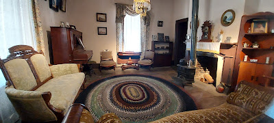 |
| The living room of the Commanding Officer's quarters |
Dad was getting hungry, and when he gets hungry, he gets
cranky (Mom always says he can star in a Snickers Candy Bar commercial). His Happy Cow app for vegan restaurants lead
us to Verde Brewery. It is in a highly
industrial area, which is a bit weird.
But it is quite a popular place, based on the attendance during our
visit. The menu, in general, is miniscule to say the least, with vegan options being a peanut butter/jelly sandwich
or nachos. Now it was my turn to get
cranky! But we were all pleasantly
surprised with how tasty the nachos were.
This place, like the Airport Mesa Grill in Sedona, uses the NexVeg
product line. The “meat” was quite
tasty. It consisted of oats, seeds, and
veggies which gave it an interesting texture (much better overall than seitan
or soy-based “meat” products in my humble rat opinion). The cheese sauce, which was potato/vegetable
based, was nice and thick, adhering to the chips as if it were melted onto
them. We all left satisfied.

Now that we were all fortified, we headed to Montezuma’s
Well, to which several American Indian tribes attribute their creation stories. The “well” was formed over the course of
millions of years. The snow and rain
that fell on nearby Mogollon Rim seeped through layers of rock and stone,
draining drop by drop, and after a few other processes, created a
sinkhole. The sinkhole contains 15
million gallons of water, though no fish call it home because it has high
levels of carbon dioxide and arsenic.
Like a bowl with a crack, however, the water seeps out of the “well”,
creating other outlets. Hohokam dwellers
channeled the water through canals to irrigate crops. The area is home to several mighty Arizona
Sycamore specimens, the tallest tree species in the State. The Creosote Bush,
the oldest plant on record, thrives here as it does in my beloved Quartzsite.
It had a fun-filled and rewarding few days, especially
since I was deputized as a Junior Ranger at Fort Verde (my first State Badge!), Montezuma’s Well, and
Montezuma’s Castle.


Though we slept a bit later the next morning, we made excellent
use of the rest of the day riding our ‘Lectric e-bikes from the Fairgrounds to Dead Horse
Ranch State Park. This is another lovely
Arizona treasure. It has decently-sized
RV sites, though only a couple in which we could fit with the swivel wheel
attached. The Park’s unusual name comes
with an interesting story. The original
ranch owners perused several properties to determine which to buy. When they arrived at this property, they saw a
dead horse lying in the road. When asked
which property they liked best of all viewed, the ranch owners’ children identified
“the one with the dead horse” as the clear winner. Not only did they purchase the property, but
the family named it accordingly. And they
stipulated to Arizona State Parks upon the sale of the land that the name “Dead
Horse Ranch” must be retained for posterity.
We traversed along 5 of the 20 trails located within the Park,
some via bicycle and some via foot. We
visited the San Luis cemetery, where up to 300 people of Mexican heritage were
buried between 1914 and 1968. The
Tavasci Marsh Trail connects Dead Horse Ranch State Park and Tuzigoot National
Monument. We hiked this
trail within the boundaries of Tuzigoot, so we decided to hike it from Dead
Horse Ranch. Quiet, shaded, and adorned
with lush plants and grasses, it offered spectacular views of Tuzigoot in the
distance. We then hiked portions of the
Jail Trail, where we picked up 2 geocaches along the way. Before
peddling back to the Fairgrounds, we stopped at Verde Lea Market/Deli/Grill,
where my/Mom’s hankering for a Sicilian hoagie was fully satisfied, and Dad
enjoyed a grilled veggie sandwich.
 |
| San Luis Cemetery |
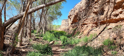 |
| Lush plants and grasses along Tavasci Marsh Trail |
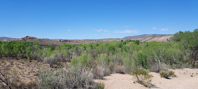 |
| View of Tuzigoot from the trail in Dead Horse Ranch State Park |
The next morning I woke up groggily from a dream in which I
was surrounded by barn animals. Apparently,
I wasn’t dreaming at all--there was a livestock event taking place at the Fairgrounds! I visited with the cows, sheep, pigs, goats,
and chickens until my parents apprised me of our day’s geocaching plans. We walked along the streets of Cottonwood,
logging 10 geocaches. We were pooped
after clocking 6 miles, but we were quite intrigued by some of the unusual
cache containers and cache locations we unveiled.
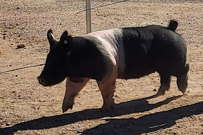 |
| One of the barnyard animals who awakened me |
 |
| A mighty unusual "paint" job on this vehicle! |
After attending Sunday services at the very welcoming Verde
Community Church in Cottonwood, we headed to Clarksdale, which was established
in 1912 for smelting copper from the mines in Jerome.
There we met up with friends
Ruth/Dale, with whom we enjoyed a picnic lunch and robust conversation. Then we all entered the Arizona Copper Art
Museum within the building that once was Clarksdale High School. What an interesting, educational
experience! Arizona is the top producer
of copper within the USA. Copper has
always had many uses: medicinal (it can
kill 99% of bacteria in 90 minutes), ornamental, even industrial. I learned that The Statue of Liberty, gifted
from France and symbolic of the freedoms and opportunities of a better life, is
comprised of 62,000 tons of copper. I was fascinated by the “trench art” on exhibit,
wherein military personnel during World War I would create adornments out of
ammunition shells. Ruth and Mom were disappointed
that the Museum did not have a gift shop.
I, on the other hand, was secretly relieved to learn that my cheese
inheritance will remain intact for another day.
We all had a wonderful day, but it was time to part ways.


 |
| Ruth/Dale and some of the "trench art" on exhibit |
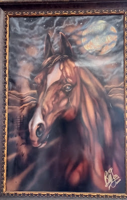 |
| This horse portrait was painted on copper! |
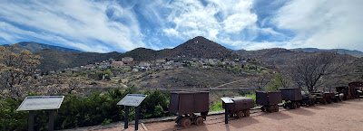
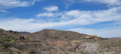
Though we were in Jerome in 2017, we decided it warranted another
visit so we could tour the Jerome Historical Park Museum, something we were
unable to do the first time around. The Museum is within the former mansion of
James Douglas, who built it in 1916 on the hill above his mining stake, Little
Daisy. I wanted to participate in yet another Junior
Ranger program, but Dad put the kibosh on it, saying I wouldn’t have enough
time to complete the booklet. Mom placated
my disappointment by watching the film with me.
Jerome sits about a mile above sea level on Cleopatra Hill overlooking
the Verde Valley. At its mining peak in
the 1920s, Jerome boasted a population of 15,000. Most of its original structures were lost to
either fire or earth-shifting rockslides.
Now it is home to 500 residents, whose art galleries, restaurants, and boutiques
offer it subsistence.
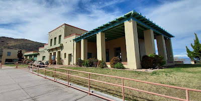 |
| The Jerome Historical Park Museum within the Douglas Mansion is one of the few original structures remaining in Jerome. |
 |
| A welcoming sitting area within the Douglas Mansion/Jerome Historical Park Museum. |
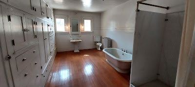 |
| For 1916, the size of this indoor bathroom simply amazes me! |
 |
| A great view of Jerome which sits atop Cleopatra Hill |
 |
| A view of the Douglas Mansion/Jerome Historical Park Museum |
 |
| Wouldn't you want a cadaver as a cab driver? |
We spent another day in Sedona. We started the day at Peace Park, where
Amitabha, a Buddhist stupa, resides.
What’s a “stupa” you ask? I
didn’t know either but learned quickly that it is a sacred place, considered a
beacon to broadcast compassion and prayer.
We followed the path for spiritual renewal, walking 3 times clockwise as
we prayed and meditated. I also learned
that the multi-colored hanging flags throughout the Park each represent a
specific prayer for humanity as well as for Mother Earth. The trailheads for Thunder Mountain and
Chimney Rock start right near the Park, so we continued our journey by hiking more
red rock of Sedona. These trails are
wonderful. They are far less busy than
the Courthouse Butte/Bell Rock area but offer views of equal splendor. Afterwards, we parked near Schnebly Place
(this lot is free of charge), walked on the pathway alongside AZ-179, and arrived
at Sedona Brewery. This place has a
unique operational system. No cash is accepted. You walk in and they immediately start a tab
on your debit/credit card. You are
greeted and given menus by a server along with a bean-filled can divided by red
and green coloring. When you want your
server’s attention for any reason (ready to order, want final check, need more
napkins, gimme another beer), you put the can red-side up. The noise from the beans in the can and the
red color would signal that you needed service.
Once your needs are met, the server puts the can green side up. I was surprised that the system worked
flawlessly (Obviously, none of the servers were old men with hearing problems
like Dad). We enjoyed our late lunch but
weren’t happy with the Sedona prices--a couple of burgers (Dad’s was veggie), 1
beer, and 1 soda cost $50, before the 20% tip!
I sure am glad Mom shares everything with me—I would hate to break into
my cheese bank for my own meal.
 |
| Amitabha, a Buddhist stupa. Each flag represents a prayer for humanity or Mother Earth. |
 |
| A statue of Buddha made from a single piece of mahogany wood |
 |
| A gorgeous mosaic bench |
 |
| The View of Sedona Valley from Thunder Mountain Trail |
 |
| Thunder Mountain Trail |
We walked off our lunch by browsing various businesses and
admiring Oak Creek Canyon. Pioneers were
drawn to Oak Creek Canyon during the Homestead Act for its year-round water
source. In the mid 1900s, Hollywood was attracted to this area for filming Westerns and other movies. Today the Canyon is home to an RV Park and a lodge. We visited
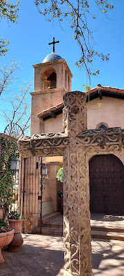
Tlaquepaque, set up like a Mexican village with stucco walls, fountains, and
even a chapel. The name “Tlaquepaque”
means “the best of everything” in Spanish, quite apropos for its upscale boutiques offering unique jewelry, artisan glassware, and other creative designs. Nearby is the Abrigados Resort and Spa, where
we went to experience a labyrinth. The
labyrinth, open to the public, is in a very small area near Creekside Park. Quite frankly, it was rather anticlimactic
for me, but it completed the spiritual journey Mom wanted to experience. We made a quick stop at the Hart Store
Historic Site. Built in 1926, it was
Sedona’s first retail establishment, selling tourist supplies, fruit from the
local orchards, and home-baked pies.
This nearly century-old building is now a curio shop and was listed
recently for sale. Any takers?
 |
| Overlooking Oak Creek Canyon. The rock formation in the center is Camel Head, to its right is Snoopy Rock. |
 |
| Tlaquepaque |
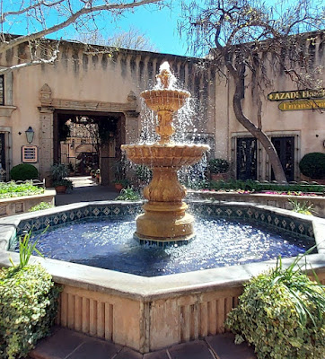 |
| Tlaquepaque |
 |
| The Historic Hart Store, circa 1926
|
Well our trip to the Sedona area had come to an
end. But more adventures await! I’ll talk to you again soon!


No comments:
Post a Comment