I was bright-eyed and bushy-tailed as we hit the road on a
crisp morning for our next destination:Capitol Reef National Park near Torrey, UT.UT-12
was a slow go with its switchbacks and steep grades from Grand Staircase-Escalante National Monument, but it just gave me more time to absorb the beauty of the landscape.After passing through Boulder,
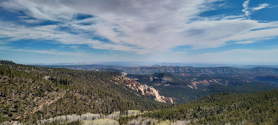
UT, the scenery changed to alpine forests.We were halfway to heaven at Heritage Overlook, 9,300 feet above sea
level yet still climbing.Remnants of
winter’s white blanket were still evident here.
View from Heritage Overlook
Soon we were on UT-24 and entering Capitol Reef National Park. We planned to spend 1 night in an RV park to pump and
dump then boondock the rest of our stay at Bureau of Land
Management (BLM) dispersed camping areas along UT-24.But one of the BLM areas would be dusty and noisy
since it was near the ongoing UT-24 road construction.The
other boondocking options along this route were congested already with
RVs, making it impossible for us to maneuver.So, we decided to stay all 6 nights at Off Road RV Resort in Cainsville, UT, about 30 miles east of Capitol
Reef National Park on UT-24. This is a new RV park, celebrating its second season.It
has HUGE full hook-up sites. Ours was so ginormous (150 feet), it could have fit 2
of our setups!We had good cell signal, and they offer free Wi-Fi, but there is no infrastructure for those who need
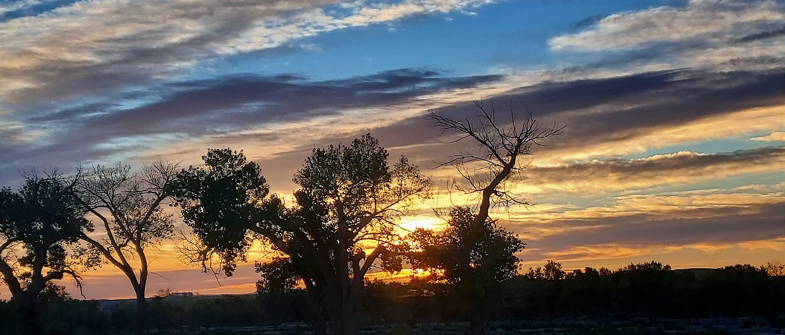
toilets, showers, or laundry. We had lovely views from the Resort, included a gorgeous sunrise. It was
a bit pricey at $50/night, especially since that rate included a 25% “early season” discount. We learned late in our stay that Off Road RV Resort offers use of their dump station to non-guests for a nominal donation. Discovering this tidbit and the many boondocking areas OUTSIDE of Capitol Reef National Park that we were not aware of initially, we could have saved some serious cheese money. But my parents were willing to shell out some bucks to support a small, local, family-operated business in their entrepreneurial endeavors.
I viewed this glorious sunrise from our kitchen window.
We set-up Suite Retreat and unloaded the
trike and side by side, fighting off the horrific winds that seem to be following
us everywhere we go.Then we went to the
next town, Hanksville, for fuel, a few groceries, and to log a geocache.While there, Big Boomer had a photo shoot
with Kathline Rock, an unusually shaped formation near Goblin Valley. Across the road, a few miniature hoodoos stood, with the snow-capped Henry Mountains towering above them in the distance.
Kathline Rock and Big Boomer
Miniature hoodoos in the foreground
Henry Mountains
We also visited Carl’s Critter Garden, where
recycled and reusable materials became art creations within an inspirational
Zen Garden.We returned to the RV Resort and took a stroll alongside the Freemont River as the sun was setting. Lots of wildflowers were blooming along the river banks.
I luv this message: "You are a child of the universe, no less than the trees or the stars...Therefore, be at peace with God, whatever you conceive him to be. Find whatever your labors and aspirations, in the noisy confusion of life keep peace with your soul. It is a beautiful world."
Freemont River
The next day we rode Maximus the Trike to the Visitor Center.We watched the informative film then rode
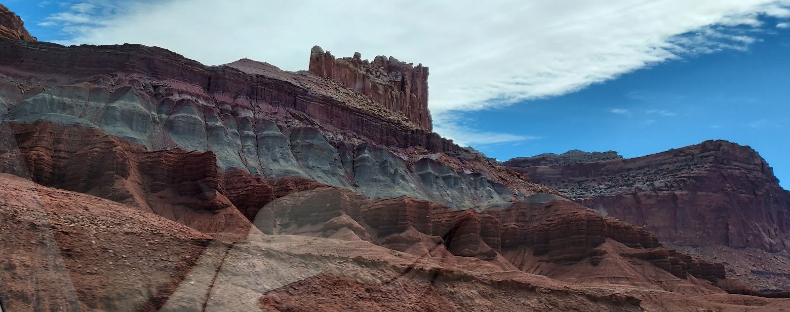
along Scenic Drive. The first 9 miles are
paved roadway, and it provides magnificent views of the Waterpocket Fold, a step-like
wrinkle in the Earth’s surface.Then Scenic
Drive turns to gravel and sand for another 2 miles.Dad didn’t want Maximus to get dusty or
dinged, heaven forbid! So, he parked the trike and we walked the balance of the road, affording us views of Golden Throne, a rock formation that towers 7,100 feet
above sea level. Then we hiked 1 mile
along the Capitol Gorge Trail to view petroglyphs and the Pioneer Register,
where early settlers carved their names/initials into the rock walls. Funny, if we do this type of "visual communication" now, it is vandalism. Yet, the "grafitti" from other centuries now is considered history. Anyway, it was getting mighty hot and I was pooping out. Good thing I stumbled upon Hyles Lineata, or, as I like to call him, Mothzilla. He occupied my attention for a little while. We returned to the parking area needing to fuel up both Maximus and our
bodies.So we went into Torrey,
enjoying a quick bite to eat at Slacker’s, a nostalgic burger joint that had a
plant-based option for Dad.We stopped
at Panoramic Point, but the views were not optimal because the 40 mph winds were
creating major dust storms, especially with the nearby road construction.
This is a good view of Waterpocket Fold.
Golden Throne in center
Capitol Gorge Trail
Mothzilla in Action
The next day we hiked the 4.7-mile Chimney Rock Loop Trail.It has a 600-foot elevation change within the
first ¾ mile, which we surmise is the only reason the Park designates it as
“strenuous”.Seeing Chimney Rock, after
which the Trail is named, was cool, but it was not the best part of the trek
for me. The highlight for me was the
spectacular panorama from the peak of the Trail.
Chimney Rock
That's Chimney Rock to the left of Maximus
Looking up at the rock formations from the bottom portion of the trail
The Creature Feature of the day was a desert spiny lizard.
Castle Rock
After lunch and refueling Maximus in Torrey, we headed to the
Boardwalk Trail to view the petroglyphs on the rock panel.Historians are not sure the meaning or
intended message of the carvings made by the Freemont Indians nearly 1,000
years ago.But based on what I saw, I
think they were saying that they encountered aliens!
There is NO WAY these carved figures in the rock represent humans!
On another day we toured the Fruita Historic District.I felt transported back in time, admiring the
heirloom orchards started in the late 1800s by the 10-12 Mormon families who settled
in this area.How courageous and
resourceful these pioneers were, dealing with the extremes of flooding and
drought on a regular basis.They worked
all year to grow their pears, apples, peaches, apricots, plums, and
cherries--from pruning dead tree branches to digging irrigation ditches, from
harvesting to canning and preserving.We
stopped at the Gifford Homestead to purchase a fruit pie as suggested in the National
Park literature, but it was after their business hours.I wasn’t too disappointed—the fruits used are not from the local
orchards.Nope, these pies are knockoffs
like the $25 Rolex watches you could get off a New York City street
vendor.However, the pies are
symbolic.They represent the culture of
the Mormon settlers, illustrating how they survived AND thrived in the area
through the fruits of their labor (pun intended).We also stopped at the schoolhouse.This little building was multi-purpose,
serving as a church and social hall in addition to the school.It started with 2 dozen students, which
dwindled to a half-dozen when its last class graduated in 1941.The land on which the school was built was
donated by Elijah Behunin, one of the early settlers.Guess it was out of necessity--he and his
wife Tabitha had 13 children, 1 of which became the school’s first
teacher.We also visited the Behunin
family cabin, where 11 of the 13 offspring lived with Elijah and Tabitha.Talk about tiny house living!
Heirloom orchards
You can purchase fruit pies during business hours at Gifford Homestead.
The deer came for a fruit pie, too, but settled for the nearby grass.
A sneak peek inside the schoolhouse window.
The Behunin family cabin, the epitome of tiny living!
Our destination the next morning was the Hickman Bridge
Trail.Though only 1.8 miles round-trip,
Mom was glad she brought her walking sticks, especially after we witnessed
someone trip and fall.This trail is
heavily populated.It offers views of a
natural bridge and of Capitol Dome, the rock formation shaped like the top of a
government building which inspired the Park’s name (to see the best views, watch my video of Scenic Drive).I often pick out shapes within the clouds and
find myself doing it with rock formations (mainly because it keeps me from
worrying about falling off the cargo compartment when we are riding!)Many
of the rocks of Capitol Reef National Park look intricately designed, as if
formed with a chisel and pick.And some
come in such vivid colors!
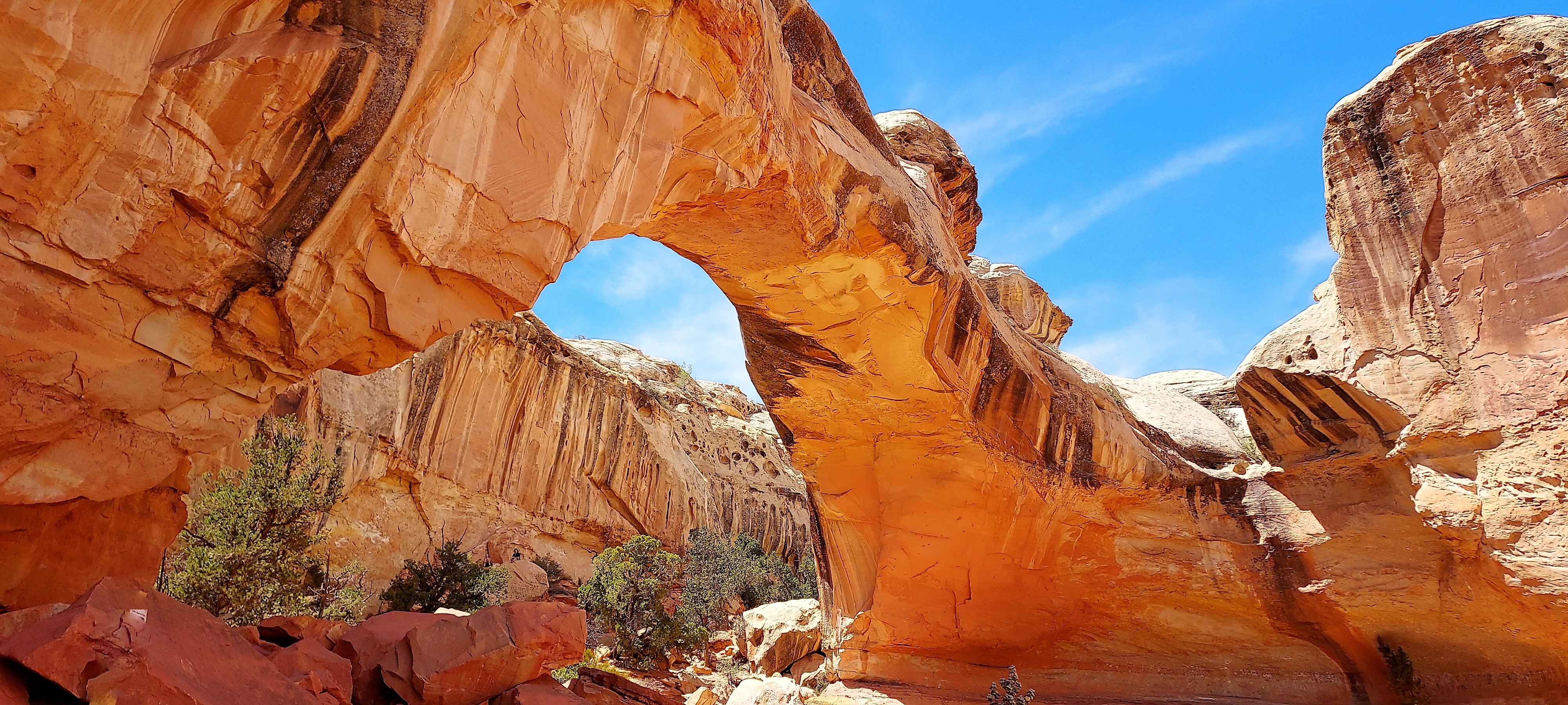
A Natural Bridge
Same bridge, different angle
Two views of Capitol Dome along the trail.
After our hike, we rode down Notom-Bullfrog Road.We discovered BLM has additional dispersed camping areas along this road.The area is popular among ATV/OHV riders.As we traversed further, we were enthralled with the thousands of acres of legacy farms and the back view of the Waterpocket Fold.We turned around after 15 miles, when the road turned from paving to dirt.But had we continued, we would have met up with the back end of the Burr Trail Road that we traversed within Grand Staircase-Escalante National Monument.
Hoodoos along Notom-Bullfrog Road
One of the many legacy farms in the foreground and the rear view of Waterpocket Fold in background.
We decided to spend our last day utilizing Rat Patrol II, our
Polaris RZR side by side. We already had a Utah non-resident OHV sticker in our possession and we were just 3 miles from Swing Arm City, an off-roader’s playground (especially for Motorcross enthusiasts) operated by BLM. We tooled around the natural bentonite clay dunes. This recreation area offers something for
every skill level, from newbies to advanced.
I was impressed watching little tykes honing their riding skills while practicing
safety--they all wore their protective gear. Swing
Arm City provides fantastic views of Factory Butte and the majestic Henry
Mountains. We learned dry camping is allowed in the area, too. We then went 9 miles further west on UT-24 to
Cathedral Valley Scenic Backway, another BLM-operated site with a small dry camping
area and off-road opportunities. We took
Trail 0082, which brought us to some awesome rock formations. One particular rock formation looked so much
like the town of Bedrock, I thought for sure I would see Fred Flintstone emerge! Since OHV’s are not allowed within the
National Park boundaries, we could not go the full 17 miles to see Temple of
the Sun, said to be a good spot for sunset.
This was a bit disappointing. But
with the sun already low in the sky, we didn’t want to be that far out by
ourselves after sundown. Anyway, Mom’s
interest had been piqued earlier in the week by a “Historic Site” sign just a
few miles before our RV Resort. We learned
Mormons started coming to the area to farm in 1883. Originally named Blue Valley, the settlement
was renamed in 1895 to honor the Mormon Bishop, Henry Giles, who once resided there. The town grew to a population of 200 in
1900. But the excessive flooding of the
Freemont River, particularly the flood of 1910, caused havoc for these folks. Devastated by the constant destruction of their
crops, the townsite was abandoned by 1919.
The sign said the ghost town and cemetery were only 2.5 miles away—I was
ready and raring to go. Then we came to
a second sign that put the kibosh on our plan.
That sign said “Flood”. The sign
did not lie—the road to Giles was completely submerged. Guess the Freemont River continues its antics
even today.
The dark spots represent the deep ruts in the clay from the OHVs climbing the dunes. Cool!
Factory Butte...
The view of Henry Mountains from Swing Arm City
Good photo of the Waterpocket fold and the vividly colored layers of rock.
This formation looked like the faces of 2 dogs to me, 1 beagle, 1 pug (uh, no, I wasn't smoking a funny cigarette).
I bet the Flintstones are here!
After reading all the info on this sign, I was excited to hike to Giles ghost town.
But alas, the rest of the road to Giles lies in the Freemont River.
Well, I've gotta run. I'll bid adieu with a photo of me, the Rambling RV Rat, proudly exhibiting my latest Junior Ranger badge. Talk to you again soon!


.jpg)


.jpg)


No comments:
Post a Comment